United States
 Argentina
  Australia
  Austria
  Brazil
  Canada
  Chile
Chile  Czechia
  France
  Germany
  Greece
  Italy
Italy  Mexico
  New Zealand
  Nigeria
  Norway
  Poland
  Portugal
  Sweden
  Switzerland
  United Kingdom
 Winter Storm/potential flooding forecasts in place over the Chicago area


Overnight rain will change over or become mixed with freezing rain and sleet with perhaps periods of snow causing hazardous travel conditions across far west and northwestern portions of the Chicago area – generally west of the Fox River Valley overnight. Potential flood-producing rains will fall elsewhere.
By Saturday morning the freezing rain/mixed precipitation/wet snow band will have crept a little closer-in. The main threat of snow still looks to occur late afternoon into the Saturday evening hours with colder air and a band of heavy snow wrapping around the back-side of the departing low pressure system.
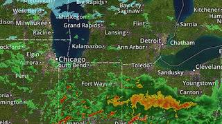
Below is a timeline of precipitation changeover forecast for several area locations prepared by the Chicago National Weather Service as well as the latest weather radar mosaic which depicts rain in green/yellow/orange-red colors, freezing rain/sleet in pink and snow in blue-white.
Winter Storm impact timeline…

Weather Radar Mosaic…