United States
 Argentina
  Australia
  Austria
  Brazil
  Canada
  Chile
Chile  Czechia
  France
  Germany
  Greece
  Italy
Italy  Mexico
  New Zealand
  Nigeria
  Norway
  Poland
  Portugal
  Sweden
  Switzerland
  United Kingdom
 Live: Metro Detroit, Michigan weather radar and traffic updates


A major winter storm is rolling through Michigan this weekend. Up to three-quarters of an inch of ice could hit some areas of the state.
The areas expected to get the most ice are between Flint and Sandusky, with accumulations between a half-inch to three-quarters of an inch possible, according to NWS meteorologist Kevin Kacan.
The ice storm warning and winter weather advisory is in effect through Saturday night.
Widespread power outages and dangerous travel are possible.
More:
Winter storm strikes Lower Peninsula, brings heavy rain, winds, flooding, ice
Massive rain storm on the way to metro Detroit could have been 10 feet of snow
The ice is a transition from rain that started Friday and caused a flood watch for southeast Michigan. The National Weather Service predicted up to 3.5 inches of rainfall, which include liquid equivalent totals for sleet and snow, too, through 8 a.m. Saturday. The highest rainfall amounts were expected to impact the area along and south of I-69.
The rain was expected to change to heavy sleet and snow Saturday morning across the northern Saginaw Valley and Thumb region as temperatures fall below freezing.
Check back here for real-time weather radar and traffic updates.
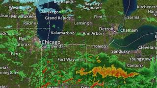
Michigan weather radar
(This GIF updates every several minutes, via NWS. Hit refresh for an updated radar. Can't see on mobile? Tap here to view the image.)
Michigan weather, traffic updatesCan't see on mobile? Tap here for live updates.
Free Press reporter Meredith Spelbring contributed to this report.
Read or Share this story: https://www.freep.com/story/news/local/michigan/2020/01/11/freezing-rain-ice-storm-michigan-detroit-weather-radar-advisory-warning/4441425002/